An Interview with Mark Moline, Ph.D.
Innovative science revolutionized Project Recover’s ability to find American MIAs and help bring them home. Project Recover partners and co-founders Mark Moline, Ph.D., Director of University of Delaware’s School of Marine Science and Policy, and Eric Terrill, Ph.D., Director of Coastal Observing Research and Development Center at Scripps Institution of Oceanography spearhead the science behind the search for MIAs.
For Mark Moline, the search for MIAs adds a human connection to his work as an oceanographer that makes it even more enticing than making a scientific discovery alone.
“Meeting the families, watching whole towns show up in the bitter cold to celebrate the young life of someone they didn’t know personally but know they sacrificed for their freedom is inspirational.” (Mark Moline)
Preparing for a Mission
Though the case for every MIA is different, each one relies on extensive research and interdisciplinary collaboration before the team goes out in the field. Project Recover only goes after cases where we have the highest chance of being successful.
Scientists work with Colin Colbourn, Ph.D., Project Recover’s Lead Historian to get a rich history of those cases. Colin researches the mission, the battles, and the MIAs. We often have letters to read; letters between parents and sons, wives and husbands. The letters tell us more about each person; their language, their character, what’s important to them. Even though we don’t know them personally, we feel a personal and emotional connection.
Sometimes, a case calls for a fairly large presence to support the science behind the search for MIAs. In Kiska, Alaska, for instance, the team needed a ship large enough to support a crew to run operations 24/7. The effort resulted in finding the USS Abner Read, the sacred resting place for 70 MIAs.
Mark and Eric work closely together, sharing people and equipment to meet the needs of the mission.


Assembling a Team
When the time comes to go into the field, Mark assembles a streamlined team to support the advanced science behind the search for MIAs. Mark’s focus is to streamline logistics and maximize the results. If possible, he likes to keep his team small and keep the equipment hand-carried so that they can work off of small boats.
Mark selects four or five people for his team filling the following roles. His team includes:
- Field Robotics Engineer: This person knows the equipment and can keep it working in the field. Mark is emphatic about this. “You have to have good equipment. You have to keep pushing the boundary of that equipment. You have to know how to use it. You need to know how to fix it in the field. The team takes a lot of time getting to locations around the globe. The last thing we want is to get there and then not be able to work or, worse, not know when the equipment isn’t working properly and giving you false data.”
- Oceanographer: This person is often a postdoctoral scholar with field-related skills
- Data System Analyst: This is someone with a background in oceanography who can analyze data gathered from AUVs and ROVs in the field.
- Underwater Archaeologist: An underwater archaeologist can interpret and document the wreckage. This person helps tell the story of the event based on the anatomy of the crash site. In addition to being helpful, we always work with the oversight of an archaeologist as a matter of integrity and respect to ensure we are disturbing sacred sites as little as possible to bring our MIAs home.
- The last spot is reserved as a learning opportunity for someone, such as a UDel graduate student or a postdoc. Typically this person has some field experience but could use more. Alternately, Mark may bring another faculty member with an interest, but a different specialty. For instance, a geomorphologist (someone who specializes in studying the seafloor) went on a recent mission. Mark said the team also has a good relationship with the U.S. Naval Academy and sometimes a midshipman will participate as well.


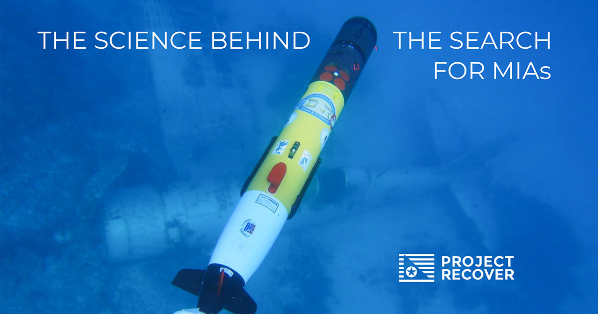
Underwater Robotics: AUVs
Underwater robotics is the key to the science behind the search for MIAs. The team uses Autonomous Underwater Vehicles (AUVs), also called Undermanned Undersea Vehicle (UUV), to find underwater crash sites. AUVs are untethered torpedo-shaped battery-operated vehicles that can map sections of the seafloor with an onboard sensors.
The AUV is equipped with side-scan sonar. The vessel pushes sound out of its sides at a glancing angle to the seafloor. The AUV then measures the sound’s return signal or reflection. Based on the intensity and shape of the return signals, scientists are able to get a picture of the seafloor.


AUVs: A Firehose of Data
AUVs send back a firehose of data. That much data also represents significant challenges. Reviewing and interpreting the information takes a lot of time. Excessive data is hard to keep up with and the team risks missing an important clue.
“The team has been preparing for years to be in the field. The last thing we want is to go over the actual site and not see it because we missed the image in a sea of data.” (Mark Moline)
The team is developing artificial intelligence to automate the data analytics to free the team to focus on targets of interest. Now, the team copes with the firehose of data, reviewing the data after each mission long into the night. They pre-program each vehicle to ‘interrogate’ (or survey) to a two square kilometer ‘postage stamp’ at a time.
AUVs are sent out in pairs for six to eight-hour missions, scanning the seafloor from maximum depths ranging from 100-600 meters. Then the team downloads the data, reviews the data while the batteries are recharging, and finally programs the mission for the next day.
Sometimes the team is going into the field with a lot of detailed documentation about the location of the crash site. In those cases, we might locate a wreck within 100-300 meters of the predicted location of the crash sites.
Other cases have less certainty. Those missions are filled with long 10-12 hour days searching methodically for multiple days in a row. The days are followed by long nights poring over data to fill in a patchwork of information and narrowing the search area.


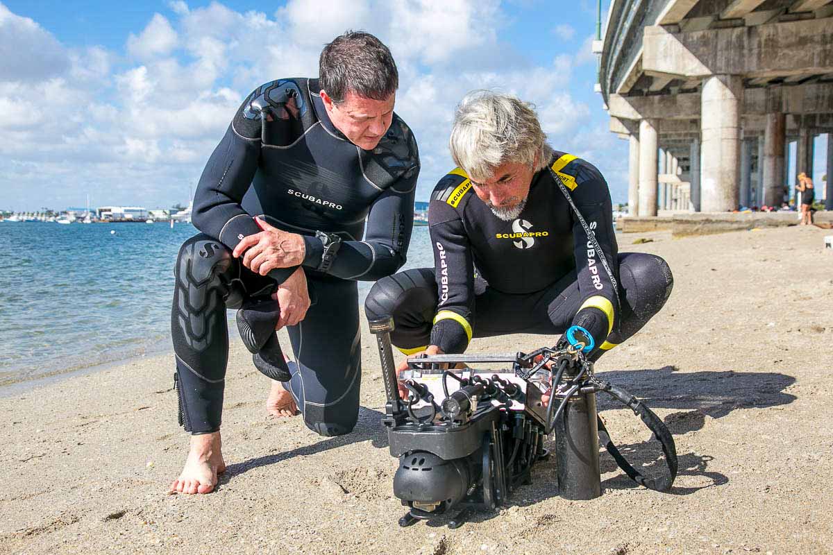
Investigating Further: ROVs
Sometimes the team finds a promising target but doesn’t know what it is. If it is deep, we’ll send down a Remotely Operated Vehicle (ROV) to investigate.
An ROV, much like an AUV, can be loaded with software and a navigation system to explore the wreck autonomously. Unlike an AUV, it is tethered to a boat for power and navigation.
An ROV has many of the same sensors as an AUV, including imaging sonar and cameras. Since an ROV uses sonar imaging, like ultrasound technology, it can get images even in turbid waters where a diver has zero visibility.
Our scientists prefer to pilot the ROV in real-time rather than program it to run autonomously. The archaeologist tells the pilot where to go to gather more data, narrow their search, and/or fill in the anatomy of a site. Data from the ROV helps the team identify plane parts. It can also look inside crew compartments.


SCUBA Diving & the Navigator
If the team finds a promising target, and it is not too deep, we will SCUBA dive on the site. UDel and Scripps team members are certified to depths of 130-150’ through a national academic diving science network, The American Academy of Underwater Sciences.
Our divers use a Navigator, an imaging sonar that allows divers to “see” up to 300’ away even with 10-15’ visibility.
The Navigator helps divers orient especially in semi-turbid waters; to know where they are and where they are going even if they can’t see it. This allows divers to maximize their bottom time which is an invaluable piece of equipment in our search for MIAs.


Mapping Science: Aircraft Clues
The science of mapping the seafloor is its own discipline.
“You have to know how sound propagates through water, how sound reacts to interference, and what different shapes and densities mean in order to accurately interpret returning sound waves.”
Manufactured objects do give some clues. A big section of an aircraft, like a tail, for instance, has more straight edges and more easily identified. An upright propeller will cast an unusually long shadow. Perfect circles, such as a wheel, don’t exist in nature. All are potential clues on a sonar image to investigate further.
Similarly, the pattern or distribution of clumps of material on a uniform sandy seafloor signals a potential clue.
However, a potential clue is just that. Nature is an opportunist and an incredible mimic. Plane parts look like coral, and underwater rock fields look like plane parts. Distinguishing between them is a product of painstaking preparation, research, documentation, and searching.
To get more clues from the ocean, Eric’s team has integrated a magnetometer into the AUV. The magnetometer detects ferrous or iron in the water and will give a signal when detected. An aircraft’s frame and its engine have elements of iron in them. When combined with side-scan sonar, it is easier to distinguish objects on the seafloor.


Anatomy of a Crash Site: Finding MIAs
The anatomy of a crash site, how the pieces of the plane are distributed, tells a lot about the event and brings us closer to finding an MIA. There are a few basic rules to understanding a crash site.
First, an airplane often no longer looks like an airplane when it crashes into the water and settles on the seafloor. A plane is made out of aluminum and may have hit the seas at high speeds. As a result, some crash sites may be quite compact, while others may be distributed over large areas, overgrown with nature, and hard to distinguish from the natural background.
Second, the dynamics of the crash directly impact the size and distribution of the crash site. Having detailed documentation about how a crash occurred helps the team know what to look for.
For example, in February 2020, Project Recover located two SBD Dauntless Dive Bombers in Chuuk. They were identical planes with very different crash sites.
One bomber was shot and hit the sea surface at max speed. That plane collapsed in on itself. Its crash site was very small, roughly 10 x 12 feet or the size of a small office.
The other bomber was flying very close to the water when it was hit. It cartwheeled across the surface of the water before it eventually sank. The resulting crash site is 600 feet long and 300 feet across at its widest. Each object in the debris field is documented meticulously.
In either case, understanding the anatomy of a crash site helps the team locate MIAs. This is especially true with larger aircraft. Fighters and carrier-born aircraft fly with a crew of one, two, or three, while B-17s and B-24s often flew with a crew of 10.
Third, knowing an MIA’s role in the crew along with the anatomy of the crash site tells us where to look. If we are looking for three MIAs in a B-24, we can narrow our search by where on the aircraft they are most likely to be. Other clues, such as a seat, parachutes, seatbelts, or an oxygen bottle will give the team clues as to where to look as well.


Preparing for Recovery: Photogrammetry
In order to document a given crash site, the team uses sonar imaging to get an overview of the entire site. In clear to fairly turbid water Project Recover also uses photogrammetry as a tool to document a site.
Photogrammetry is the process of combining multiple images into a single 3-dimensional model The team will take thousands of high-resolution pictures of the entire wreck site to generate this single model of the site. The software itself geometrically corrects the images – or orthorectifies them – to ensure they are uniform and to scale with each other. Then, based on the fused angles and overlapping points, the software back-calculates where you took the picture relative to the wreck. The model can then be used to generate any view of the site or part of the site for further investigation. The model is also provided to the recovery team, which allows them to identify priority areas virtually before they even take off for the mission.


Meeting MIA Families
“Pat used to tell us ‘Just wait until you meet the families,’” Mark said. “Sure enough, that is the carrot that pulls you along.”
It takes approximately six months for Project Recover to plan for a mission, and another six months to find the site and document it.
“There is a real transcendent moment when you do actually find the site. It is not only an objective, but there is a lot of emotion behind it as well.” (Mark Moline)
After that, Project Recover turns all the crash site documentation over to the Defense POW/MIA Accounting Agency, who makes the decision on recovery of a particular site. When remains are found, DPAA is tasked with identifying the service member and notify the next of kin. When the MIA is finally returned to the family, DPAA introduces Project Recover to the family.
Project Recover is frequently invited to participate in the interment ceremonies. There, we finally get to meet the families of MIAs we’ve come to know in ways that feel very personal. We see and experience the impact MIAs have on the families, even decades after their deaths. Regardless of the weather, people of all ages show up, line the streets, hold back tears, and wave flags to welcome our MIAs home.
Our MIAs inspire a human connection and an emotional response. Bringing them home is not just the right thing to do, it creates a mechanism for dialogue. Silently, they speak of unity, love, gratitude, and hope.
There is a human connection that becomes obvious to, not just us, but everyone we meet.
“It is a reinforcement that what we are doing is really worthwhile. It drives us to want to know more, help more MIA families, and do more and more of this work.” (Mark Moline)
Personal Connection: Grandfather was a WWII Chaplain
Mark Moline has a personal connection to World War II MIAs as well. His grandfather, O. Karl Olander, was a Chaplain in the US Navy Reserves. Though he didn’t talk about his service much, Mark’s grandfather kept a diary and scrapbook of his wartime service.
Before Mark left for Palau in 2014, he received the written narrative of his grandfather’s legacy; the diary and scrapbook. In it, he read about his grandfather’s service aboard the USS Princeton during the battle against enemy forces in Palau.
His grandfather wrote about a ‘flyer’ they lost one day in battle. The young man had sat in the front pew of his last church service. He was Missing in Action.
It turns out Project Recover was investigating the very same case as they prepared for their mission to Palau.
Project Recover is methodical about the cases it pursues.
“We go after the best cases based on historical information, logistics, and the possibility of success.”
Still, Mark admits, this family connection adds a new intrigue. He can’t help but hope the team finds this particular MIA.
“It would be something to meet his extended family.”
Project Recover Partnership
Project Recover’s partnership with Mark Moline and Eric Terrill dates back to 2013. At that time, Mark and Eric were in Palau developing hydrographic models to show how water flows around the island nation. (Through their work as partners with Project Recover, they continue to give host nations valuable information about their natural resources).
In 2013, Pat Scannon and the team, then the BentProp Project, were in Palau as well. They were searching for MIAs. At that time, instead of innovative science, they were using standard but rudimentary underwater search methods. Divers were pulled along by a boat while scanning the bottom, spaced along the seafloor, or swam in a circle hanging on to a rope.
When they saw what Mark and Eric were doing, they were intrigued about applying their innovative science to the search for MIAs. Mark and Eric, for their part, were excited about integrating the human element with science in support of military families.
The next year, the trio and their respective teams went out on a two-hour mission together. They located an underwater Japanese WWII wreck. It was enough to get everyone excited.
They formed an informal partnership and, in 2014, they met in Palau again. This time, they had a plan to search for two planes in particular; a TBM Avenger piloted by Lt(jg) John Savage and an F6F Hellcat piloted by Lt. William Q. Punnell. BentProp had been searching for them since 2005 and 2004, respectively.
In 2014, after significant prep time and years of searching and documentation, the trio found both aircraft in “about an hour each.”
“It was great teamwork and showed the combined skills of the entire group, including Pat’s team as well as mine and Eric’s. We were hooked after that.”
Pat, Mark, and Eric understood the possibilities. Together, they expanded their effort which led to larger donations and more field operations. They formalized operations in 2016. The BentProp Project formally became Project Recover in 2018.
Read More:
- Finding MIAs: The Impact on MIA Families
- Stockbridge Underwater Robotics Team in Palau
- From One Man’s Vision to Every American’s Mission


Great presentation about how far you’ve come since integrating with BentProp. Thanks again for the tour of your Palauan “lab” back in 2015.
Ted Mikita
Dixon B-24
What a great article. Keep up the great and important work.
Elizabeth
Thank you Elizabeth!
You all are amazing. It’s fascinating.